Entry Points:

About Apache County
Apache County covers a tall, skinny stripe of land extending from the northeast corner of Arizona that extends southward more than halfway through the state. The Navajo Nation Indian Reservation includes more than half the county on the northern end. The Fort Apache Indian Reservation includes the southwest corner, and the Zuni Indian Reservation also has a small unit in the county. Part of Petrified Forest National Park lies on the western boundary and the Canyon de Chelly National Monument is entirely in the county.
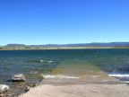
The elevation is generally high, above 5,000 feet. The Carrizo and Lukachukai Mountains in the northeast reach to nearly 10,000 feet in elevation, as do the White Mountains on the southern boundary. The beautiful Escudilla Mountain, on the New Mexico border, can be seen for a hundred miles to the north on a clear day. A great plain covers the area north of the White Mountains up to the Puerco River. The Puerco River crosses the county near its center. North of it, the land is more hilly and rugged with deep canyons in some places.
Apache County was created in 1879, and now covers 11,208 square miles. Navajo County, to the west, was divided off of if in 1895. It is the sixth largest county in land area in the continental United States. The population in 2000 was 69,423 and the county seat is at St. Johns.
What to See in Apache County
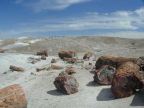
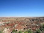
Petrified Forest National Park
Petrified Forest National Park preserves one of the world’s largest deposits of petrified wood, laying in their natural state on the desert floor. They are in a variety of sizes including whole tree, one hundred feet long, in one spot, laying as they fell. Often the bark on the trees, and the grain in the wood can be seen, along with beautiful crystalized colors. The park also includes the Painted Desert, and offers numerous trails and historic and interpretative sites.
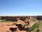
Canyon de Chelly
Canyon de Chelly National Monument is a cliff-lined network of canyons where ancient Anasazi Indians built cliff-dwellings, and todays native Americans still farm and live. The breathtaking views can be enjoyed from the North and South Rim Roads and guided tours of archeological sites in the canyon are available.
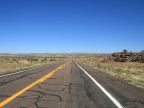
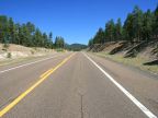
See also the beautiful forests of the White Mountains around Alpine and Nutrioso. See ruins in the one-time frontier town of Concho, or the orderly settlement of the Mormons at St. Johns and Eagar, which continue to be a thriving communities today. The entire length of U.S. Highway 180 through Apache County can be seen in this tour, as well as all of U.S. Highway 191 from Sanders to Alpine.
For More Information:
See the official site of Apache County at www.co.apache.az.us, and Wikipedia’s Apache County article.