Entry Points:

About Gila Bend
Gila Bend is named for a bend in the Gila River, which approaches from the north to a point a couple miles north of Gila Bend, and then turns westward. The Gila River is a major river of central Arizona, but due to the high need of water, little (and sometimes no) water is left to flow through it. It joins the Colorado River further west.
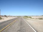
The elevation at Gila Bend is just 737 feet, quite low for its inland location. Combined with its southern location and the dryness of the surrounding desert, it has a very warm climate with temperatures frequently reaching above 100, and rarely below freezing. It is surrounded by miles of flat desert country, with small mountains on the horizons. Creosote bushes, with their small, dark green leaves and yellow flowers, dominate the scenery out of town, while palm trees and other small trees have been cultivated in the town.
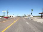
Gila Bend was founded in 1872 and wasn't incorporated until 1962. It is in Maricopa County, and the only town in the southwest corner of the county. Interstate 8 passes along the south side of town, and services for travelers is a major part of the local economy. Arizona Highway 85 heads north and south from Gila Bend, south to Ajo, and north to Buckeye. The historic alignment of U.S. Highway 80 passes through Gila Bend. This highway used to follow the Gila River, but was replaced by the interstate. It can be followed through a farming district north of town, and parts of it remain along the freeway to the west.
The Barry Goldwater Air Force Range occupies a large area to the south of Gila Bend.
For More Information:
See Gila Bend’s official site at www.gilabendaz.org and Wikipedia's article on Gila Bend.