Entry Points:

About Ehrenberg
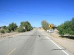
Ehrenberg is an unincorporated community next to the Colorado River in western Arizona. It is mostly scattered along the road which in Ehernberg is called Ehrenberg-Parker Road, but after leaving town to the north, it is called Mohave Road. Interstate 10 passes by the south end of Ehrenberg, and a number of services for freeway travelers is located at the one interchange. Immediately after passing Ehrenberg, the freeway crosses the Colorado River on a large bridge.
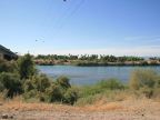
Farmland surrounds the Colorado River, especially on the California side, where the wide Palo Verde Valley lies. A narrow band of farmland lies between Ehernberg and the river on the Arizona side. Beyond the farmland, the land rises slightly and becomes hilly. Ehrenberg lies along this ridge. Native desert vegetation, including creosote bushes and mesquite trees, cover the land from there for several miles eastward. A range of low, barren mountains lines the eastern horizon.
Mohave Road, after leaving town to the north, enters the Colorado River Indian Reservation. Here it passes through a large farming area, scattered with farmhouses. Beyond this it arrives at Parker. Interstate 10, after crossing the Colorado River, quickly comes to the city of Blythe. The land outside the farming areas is mostly an uninhabited wilderness.
The climate at Ehrenberg is hot and dry. It was 92 degrees on the 28th of April when these pictures were photographed, and it can reach 110 degrees in seven months of the year. In winter temperatures rarely drop as low as freezing. Rain is almost unheard of in winter and averages less than an inch in any month.
Ehrenberg was settled as a crossing of the Colorado in the late 1800s, and was important in early shipping routes as well as migration to California. It was named after Herman Ehrenberg, an early explorer of the area at the time of the Gadsden Purchase. A pioneer cemetery in Ehrenberg is the burial site of many who didn't make the crossing successfully.
The elevation at Ehrenberg is just above 200 feet, and its population was 1,357 as of the year 2000. U.S. Highway 60 used to pass through Eherenberg before it was replaced by Interstate 10, and parts of its alignment can still be seen.
For More Information:
See the Wikipedia article on Ehrenberg.