Entry Points:

About Greenlee County
Greenlee County is mostly filled by Coronado Mountain and the long high ridge that lies to the north of it, a tall, steep-sided mountain where travel is difficult. The huge Morenci Mine occupies the south end of this mountain, and the county seat, Clifton, and other communities are wedged in between the cliffs, the mine dumps and the highway. A sliver of the county extends further south into the deserts.
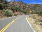
U.S. Highway 191 passes north-south through Greenlee County, but north of the Morenci Mine it is very winding with speed limits around 30 MPH for much of the way. The scenery is stunning, with overlooks of the desert far below, and beautiful alpine forests further to the north. U.S. Highway 70 crosses the southern tip of the county.
Greenlee is the least populous county in Arizona at 8,547 people (2000 census). It covers 1,848 square miles.
Street Index
|
U.S. Highway 191 |