Entry Points:

About Kaibab Mountains
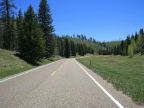
The Kaibab Mountains, also known as the Kaibab Plateau, begin at the North Rim of the Grand Canyon and extend fifty miles northward. Surrounded by deserts in every direction, heavy winter snows (as much as 200 inches) fall in these high elevations, (up to 9,241 feet). Forests of ponderosa pine, other evergreens, and quaking aspen cover the mountains, along with alpine meadows and lakes
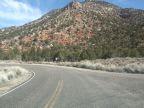
Even without the proximity of the Grand Canyon, the Kaibab Mountains would offer a wealth of recreational opportunities with numerous campgrounds and hiking trails and many miles of backcountry roads. State Highway 67 follows the ridge of the mountains southward from its junction with U.S. Highway 89A at Jacob Lake to the rim of the Grand Canyon, providing the main access to the area.
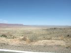
The tops of the Kaibab Mountains are not jagged peaks, but a long ridge carved into rolling, forested hills by numerous minor canyons. From a distance, they appear as a long, flat, dark-colored ridge. To the east lies the House Rock Valley, and the Arizona Strip lies to the west.