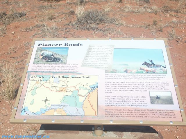
Pioneer Roads
U.S. Highways 89 and 89A parallel the original route of the Old
Arizona Road. This route was travelled many times by frontier
scout Jacob Hamblin searching for a safe route to Lees Ferry and
beyond. Imagine yourself traveling the Old Arizona Road on
horseback or covered wagon as ou continue your journey today.
Before paved roads, and air-conditioned autos, life along the Arizona Strip
was more than hard. Pioneers, ranchers, and miners desperately needed
communication and transportation linkages with the outside world.
Through the late 1800's, the Old Arizona Road linked settlements along the
Little Colorado River to southern Utah through Lees Ferry and Kanab. It also
linked Arizona settlements to St. George, Utah, through Fredonia. Pipe
Springs, and the Arizona Strip. Arizona towns like Snowflake and St. Johns
sprung up aftr exploration of this route by Jacob
Hamblin.
When the St. George Temple opened in 1877,
many faithful members of the Mormon church
traveled the rugged Old Arizona Road to be
married in the temple. This portion of the road
soon became known ast the "Honeymoon Trail."
You are traveling on the only paved road across 2.8 million acres of public land
managed for a variety of uses by the Arizona Strip Bureau of Land Management.
In the interiior of the Arizona Strip you will find 4,000 to 5,000 miles of unpaved
road which require advance travel planning and precautions to ensure a safe trip.
"We found but little grass and no
water to speak of, occassionally
there was a little in holes along the
bed of the river, but it was so salty
that it could not be used. We dug
near the mouth of some of the
large washes that came in where
we found some water that was a
little better. At Black Falls we
found a little but it was not fit to
use as the fish had died in it and it
smelt very bad like carrion.
--Joseph Fish, 1879
Don't miss the rest of our virtual tour of Coconino County in 21660 images.